About High West Jesmond
High West Jesmond was originally part of estates owned by the Dukes of Portland.
Dukes of Portland

The title Duke of Portland was created in 1716 but became extinct in 1990 upon the death of the ninth Duke.
The earlier title Earl of Portland was created for a second time in 1689 in favour of William Bentinck, the Dutch favourite and close advisor of King William III.
The first earl was succeeded in 1709 by Henry, his son from his first marriage. In 1716, he was created Marquess of Titchfield and Duke of Portland.
His grandson, William Cavendish-Bentinck, 3rd Duke of Portland was a noted politician. He was Prime Minister in 1783 and from 1807 to 1809 and also served as Home Secretary and as Lord President of the Council.
In 1801, he assumed by Royal licence the additional surname of Cavendish. Portland was the husband of Lady Dorothy Cavendish, daughter of William Cavendish, 4th Duke of Devonshire, and was a descendant on his mother’s side of Henry Cavendish, 2nd Duke of Newcastle-upon-Tyne.
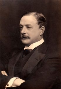
William Cavendish-Bentinck, 6th Duke of Portland

William John Arthur Charles James Cavendish-Bentinck, 6th Duke of Portland (1857 – 1943), known as William Cavendish-Bentinck until 1879, was a British landowner, courtier, and Conservative politician. He notably served as Master of the Horse between 1886 and 1892 and again between 1895 and 1905 under Lord Salisbury and Arthur Balfour.
He inherited the Cavendish-Bentinck estates, mostly based around Welbeck Abbey in Nottinghamshire, in 1879. He also succeeded his stepmother as second Baron Bolsover in 1893. His half-sister Lady Ottoline Morrell was a society hostess and patron of the arts associated with the Bloomsbury Group (or Bloomsbury Set).
Portland initially embarked on a military career and served as a lieutenant in the Coldstream Guards from 1877 to 1880, and as lieutenant-colonel of the Honourable Artillery Company from 1881 to 1889.
Development of Land at High West Jesmond
William Cavendish-Scott-Bentinck, the 5th Duke of Portland was the first to dispose of estate lands at High West Jesmond:
- 17 Jan 1863 – Duke of Portland to Blyth and Tyne Railway Company – land for construction of railway
- 16 July 1874 – Arthur Charles Greville and Edward Bailey and Duke of Portland to Blyth and Tyne Railway Company – certain roads and bridges were agreed to be made by the Company for the benefit of the Jesmond Estate
The Blyth and Tyne Railway
The Blyth and Tyne Railway was a railway company in Northumberland, England. It was incorporated in 1853 to unify several private railways and waggonways that were concerned with bringing coal from the Northumberland coalfield to Blyth and to the River Tyne. Over the years it expanded its network to include Ashington, Morpeth and Tynemouth. As coal output increased the company became very prosperous in hauling the mineral to quays for export, and in addition a residential passenger service based on Newcastle built up. It was absorbed by the much larger North Eastern Railway in 1874.
1888, 1898 and 1904 sales
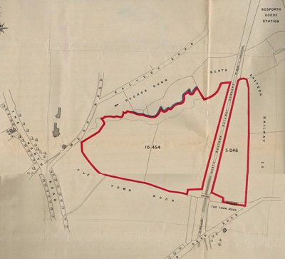
Further land was disposed in 1888 and 1898 and then in 1904 William Cavendish-Bentinck 6th Duke of Portland and Edward Horsman Bailey and Charles Ludovic Lindsay sold further land at High West Jesmond on both sides of the railway line on:

22 Sept 1904 – to Mr James Forsyth of Elswick Court, Northumberland Street in the City and County of Newcastle upon Tyne who was the purchaser of
Firstly 16.454 acres or thereabouts bounded on or towards the north partly by land belonging to George Dunn and partly by land of the North Eastern Railway Company on or towards the east by the Blyth and Tyne Branch of the North Eastern Railway and on or towards the south and west by the Town Moor of the City of Newcastle upon Tyne; plus
Secondly 5.046 acres or thereabouts bounded on or towards the north and east by land of the North Eastern Railway Company on or towards the south partly by the Town Moor aforesaid and partly by land of the North Eastern Railway Company used as an embankment and bridge approach and on or towards the south by the said Blyth and Tyne Branch of the North Eastern Railway.
Sold and developed in stages
The acquired land was sold in various stages by James Forsyth often accompanied by plans for the construction of dwelling houses as the buildings around the newly laid out streets of High West Jesmond were built.
Much of the building work took place during the early years of the 20th century and High West Jesmond was mostly constructed before the outbreak of the Second World War in 1939.
About Jesmond, Gosforth and the Town Moor
Jesmond
In the twelfth century the manor of Jesmond was given by Henry I to Nicholas Grenville whose family built the first manor house.
St Mary’s Chapel was built around the same time which subsequently became a famous shrine, attracting pilgrims from all over the country.
According to local tradition recorded on Wikipedia, sometime shortly after the Norman conquest there occurred in the valley of the Ouse an apparition of the Blessed Virgin Mary. It was believed that the Virgin held the infant Christ, because up until that time Jesmond had been known as Gese Muth “the mouth of the Ouse” but afterwards it was known as Jesmond, popularly interpreted as “the hill of Jesus“, or “Jesus Mound“.
St Mary’s Chapel fell into ruin during the reformation.
The chapel ruins are in Jesmond Dene on the west side of the valley. The ruins and its grounds later passed through various owners and it was acquired along with the dene or valley of the Ouseburn by Lord Armstrong in the 19th century.
He fenced in the dene, planted trees and shrubs, built bridges across the stream and laid out walks along its banks. Having given the neighbouring Armstrong Park to the city in 1880, Lord Armstrong presented Jesmond Dene to the City of Newcastle for use as a public park.
Until the middle of the nineteenth century Jesmond was a mainly agricultural area with several small coal mines. It gradually became a suburb of Newcastle upon Tyne and was formally added to the city in 1835.
Jesmond became home to Newcastle’s shipbuilders, shipowners and other captains of industry who built their homes such as Jesmond Dene House (designed by Newcastle architect John Dobson and formerly home of industrialist Sir Andrew Noble who was a partner of Lord Armstrong, now a hotel) and Jesmond Towers (originally called West Jesmond House which was bought around 1870 by shipbuilder Charles Mitchell who enlarged and renamed the house, his family lived there until the early 1900’s home to La Sagesse High School until it was closed for development into housing.
Jesmond Towers was also used as a set for the Dumping Ground in the popular children’s television series Tracy Beaker Returns, starring Dani Harmer.
Osborne Road was laid out in the 1860’s and 1870’s
Over time these large homes were surrounded by suburban housing as horse-drawn trams and later on electric trams made the journey to the centre of Newcastle easier.
Jesmond Dene Real Tennis Club is one of only 27 Real Tennis courts in the UK and 46 in the world (Australia 5, France 3, USA 11). Built in 1894, the court is situated on Matthew Bank on the east side of High West Jesmond.
Jesmond Lawn Tennis Club on Osborne Road was founded in 1883 and has a long and distinguished history which includes member Muriel Robb winning Ladies Singles at Wimbledon in 1902.
Gosforth
High West Jesmond is the northernmost part of Jesmond and for a long time formed the northern boundary of the City of Newcastle (hence the seemingly abrupt change of name of a straight road from Ilford Road, NE2 to Rectory Avenue NE3).
North of High West Jesmond is Gosforth which was a separate local authority (Gosforth Urban District Council) constituted in 1895 to 1974, when as part of local government reorganisation it became part of the City of Newcastle upon Tyne.
The origin of the Gosforth name is thought to have come from the title Gese Ford, meaning “the ford over the Ouse”, referring to a crossing over the Ouseburn, but others think that it comes from the Old English Gosaford, meaning “a ford where the geese dwell”, and it is first recorded as Goseford in 1166.
According to the 19th century publication, A Topographical Dictionary of England, the township of Gosforth was held of the crown by the Surtees family from 1100 to 1509, when it passed by marriage to Robert Brandling. In the 18th century the Brandling family were one of the regions powerful coal owners.
The modern centre of Gosforth on Gosforth High Street was originally known as Bulman Village, which was constructed in 1826 on land given by Job James Bulman to provide voters to support him in a local election.
In 1864 Gosforth was connected to the Blyth and Tyne Railway. In 1905 the Ponteland Railway was opened from Gosforth to Ponteland. Three stations in Gosforth were on this route, South Gosforth (the 1864 station renamed), West Gosforth and Coxlodge.
With the opening of the Tyne & Wear Metro system in the 1980s the locations of these stations were used for the modern South Gosforth, Regent Centre and Fawdon stations respectively.
High West Jesmond is also served by the Metro with a station at Ilford Road which was built for the opening of the Metro in 1980, half way between West Jesmond and South Gosforth, which were both original LNER stations. The control centre for the Metro system is located just up the rail line at South Gosforth station, with the main depot and train sheds located nearby.
The Town Moor

The Town Moor is a large area of common land covering an area of around 1,000 acres or 400ha, which is larger than Hyde Park and Hampstead Heath combined, and also larger than New York City’s Central Park.
At the south-eastern corner lies the Exhibition Park, but the rest of the Town Moor is not laid out as a park and is mostly treeless. The Freemen of the city have the right to graze cattle on the moors, the rental income is distributed through the Town Moor Money Charity.
The ornithologist and landscape architect John Hancock, after whom the nearby Hancock Museum is named, produced a planned layout for the Town Moor in 1868, which was only partly realised.
The Hoppings, said to be Europe’s largest travelling fun fair, is held on the Town Moor during the last week in June.
The area of common land is actually split up into several sections, of which the Town Moor is but the major part. The area is intersected by the A189 road and the section on the other side of the road is known as Nuns Moor, and includes the Newcastle United Golf Club. Also part of Town Moor are Dukes Moor and Little Moor, both at its northern end, Hunters Moor to the west, and Castle Leazes Moor to the south.
The Town Moor first hosted horse racing events in 1721. The Town Moor’s course was approximately two miles long, a triangular shape and located at the northern area of the moor, just south of Gosforth.
Part of the course ran through a cutting which can still be seen in the grass at the north of the moor. In 1800 a permanent stone grandstand was built at the north end of the racecourse; a fire damaged it for a short time in 1844. The road in front of this grandstand is still called Grandstand Road to this day. From 1833 the Northumberland Plate horse race was hosted at the Town Moor until 1881 when racing moved to Gosforth Park where the racecourse remains today.
