Vandalism and anti-social behaviour

Regrettably our normally peaceful area has recently been suffering from regular visits by a gang of youths who have been causing trouble and damaging cars and windows as they walk from Ilford Road metro to Jesmond Dene.

HWJRA spoke with all three of our local councillors and they in turn spoke with Northumbria Police and Nexus (who own and operate the Tyne & Wear Metro). 

We don’t want to tempt fate, but since the arrival of police horses to intercept the teenagers and, following the arrests of seven youths, we don’t appear to have had any more trouble. 

The police and Nexus are also continuing to patrol the metros to prevent this happening again in the future.

We have invited Northumbria Police to attend our AGM on the 8 April 2019 so that we can discuss this and any other issues affecting the area.

HWJRA would like to thank everyone involved in bringing this nasty episode to a conclusion.

Read our earlier article on Anti-social behaviour on this website.

You can read more on the Chronicle website – ‘Even the parents can’t control them’: The teenage tearaways making life near the Metro miserable

Residents parking

There has been an ongoing and rather lively debate on the HWJRA Facebook page about the pros and cons of residents’ parking in our area.

Live in High West Jesmond? why not join our HWJRA Facebook group

It’s fair to say that opinion is divided on this matter with those people living on streets near to the metro and bus stops (Albury Road, Moorfield, Ilford Road) more likely to be in favour than those who do not.

The council last tested local opinion on this matter in 2010 and are prepared to do so again, however before they can put the issue of residents’ parking to a local poll they need to conduct an assessment of the current parking density in the area.

HWJRA has pointed out to the council that if they were to do an assessment right now then it might be misrepresentative of what is about to happen.

This is because, under the Streets for People proposed changes to Ilford Road and Moorfield, a number of parking spaces would be lost on both roads with the likely net result that the parking density in the middle part of Moorfield would become even greater.

We have therefore suggested to the council that they either factor this in to their calculations or they delay the assessment until the Streets for People work is completed. We will keep you updated on this.


Moorfield and Ilford Road proposals revealed

Proposals for changes to Moorfield and Ilford Road roads have been revealed by Newcastle City Council following the earlier public consultations under the Streets for People initiative.

Drop in session on 19 March 2019

A public drop in session is being arranged by Newcastle City Council for the public to see the Streets for People proposals on Tuesday 19 March 2019 3pm – 7pm at Jesmond Library, St George’s Terrace.

Newcastle City Council has spent the time since the public consultation on original proposals were issued in October 2017 converting the findings from the public consultation and internal council consultations into briefs to amend the original drawings in the neighbourhood plans for Heaton & Ouseburn; Jesmond; & Arthur’s Hill & Fenham.

The Council’s Streets for People website January 2019 update says that the amended scheme drawings have been  “thoroughly costed so we have a much clearer idea of what is affordable and achievable within the available budget”.

“It was always our intention to propose a greater number of schemes than we had the budget for, thereby creating a sub set of ‘go to’ proposals in each area that could be brought forward in the event of other funding being identified.”

Newcastle City Council has discussed the options for each area with the Streets for People reference groups and fed this back to local Ward Councillors who have determined the following shortlisted schemes to progress to formal consultation and delivery.

Jesmond proposals

The proposals in Jesmond are as follows:

  • Traffic calming and junction improvements along Moorfield and cycle track on Ilford Road between Jesmond Dene Road and Moorfield;
  • Pedestrian crossings and cycling facilities on Osborne Road at the junctions with St George’s Terrace and North Jesmond Avenue;
  • Raised tables to improve the experience for people walking or trying to cross at the road ends along St George’s Terrace;
  • Closing Norham Place to motor vehicles near the junction with Mistletoe Road; and
  • Decluttering Brentwood Avenue to improve the pedestrian experience and adding some cycle parking near the shops.

You can read about proposals for other parts of Newcastle upon Tyne on the Streets for People website.

Moorfield and Ilford Road proposals

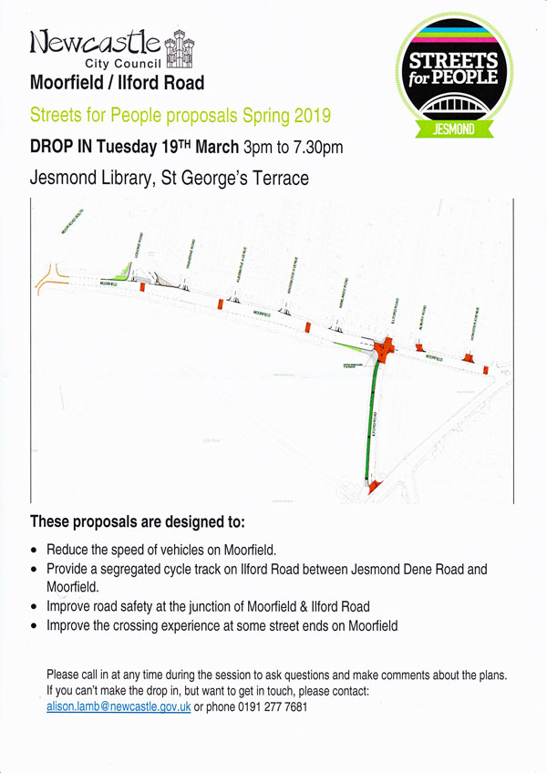
The principal objectives behind the changes are to reduce the speed of traffic on both roads and to improve pedestrian and cycling safety.

Many of you may remember that it was originally proposed to narrow Moorfield by adding a wide cycle lane along its full length.

Whilst there was widespread support for the objectives of reducing speed and increasing safety, the reaction of local residents to the significant narrowing of Moorfield was strongly negative.

High West Jesmond Residents Association were therefore pleased to learn that the Council has reacted to the feedback that they received and has produced a revised proposal that maintains the current width of Moorfield for most of its length.

The Council has advised that full details of the proposal are going to be made available shortly, and have organised a “drop-in session” at Jesmond Library on Tuesday 19 March from 3pm – 7.30pm so that local residents can take a look at the detail of the proposals and comment on them.

Our understanding is that the proposals will include:

  • The introduction of a cycling lane along the west side of Ilford Road from Jesmond Dene Road to Moorfield
  • Tightening of the junction at Moorfield/Ilford Road and introduction of a raised platform to slow traffic as it crosses this junction along and across Ilford Road
  • Introduction of three speed ramps along Moorfield to reduce the speed of traffic along this road
  • Some amendments at the junction of Moorfield and Moor Road South to make this junction safer (we have not yet seen the details of this part of the proposal).

We will make the plans available via our website and the notice board on Newlands Road as soon as they are available from the council.

You can download a copy of the leaflet Newcastle City Council has issued for the drop in session on Tuesday 19 March 2019.

Statutory consultation process

The Streets for People website also states that “We recognise that some people involved in this process may not agree with the shortlisted schemes, and appreciate they will have their own preferences. We also recognise that the delivery of the above schemes are subject to statutory consultation processes and it is clear that some will be significantly more controversial than others. We hope we can rely on your ongoing engagement with the process to get a range of improvements delivered.”


Haddricks Mill roundabout improvements to start

Work is to start shortly to improve Haddricks Mill roundabouts in South Gosforth.

The improvements are part of Newcastle City Council’s plans to improve key junctions across the city from the Blue House Roundabout, Jesmond Dene Road to Haddricks Mill and beyond.

You can read more about the previous plans from August 2016 for the Blue House Roadabout and Jesmond Dene Road elsewhere on this website.

The upcoming Hadricks Mill improvements were also opened for public consultation in August 2016, although the work that is now to take place is much less than the original plan to widen the Haddricks Mill junction and replace the existing 2 roundabouts with 1 substantially larger roundabout.

You can read more about what Newcastle City Council plan below.

The following announcement has been made by Newcastle City Council:

Haddricks Mill double roundabout in South Gosforth is set to benefit from £4m investment to improve safety and congestion through an upgrade of the ageing infrastructure in the area.

A well-known collision hotspot Haddricks Mill also suffers from congestion, delays and safety issues – particularly in relation to cyclists.

Six roads converge

Six roads converge onto the junction which is used by tens of thousands of commuters each day, with queues building up at peak periods, leading to longer journey times and affecting air quality in the area.

The major investment will renovate the bridge the junction sits on, realign traffic lanes to improve lane discipline, re-position the mini-roundabouts to increase capacity and install new crossing facilities that will help balance traffic flow in peak periods.

This should have the added benefit of reducing high levels of congestion and improving air quality.

Cllr Arlene Ainsley, cabinet member for transport and air quality said: “Haddricks Mill is a notorious junction and I am pleased it is to be given a much-needed overhaul.

“This is a major safety and infrastructure upgrade scheme, designed to improve safety and smooth traffic flow at peak periods – reducing congestion and encouraging more sustainable choices of travel – which should improve air quality.

“Due to the junction’s location over the Ouseburn and several businesses lining the approaches, the options available to improve it are limited but we have designed a scheme that delivers safety and congestion improvements for one of the key routes into the city and which takes into account residents’ feedback from our earlier consultation.”

The works are a scaled-down version of the proposals the council consulted on in 2016 and addresses many of the concerns raised by residents such as the size of the junction, changes to access to a local housing estate and proposed banned turns and movements.

Work will last until 2020

The council plans to take advantage of the current closure on Killingworth Road to start preparatory work on the junction, reducing the disruption to commuters before the main works start.

The main programme of work to the carriageway will be begin this spring and should last until early 2020.

However, the council is committed to minimising disruption and keeping two-way traffic on all approaches – apart from occasional night-time and weekend closures for resurfacing towards the end of the programme.

Minor tree removal is necessary with up to ten trees needing to be removed as part of the scheme, but the council will replace them with at least 30 trees to further improve the environment.

The full package of improvements includes:

•           Water-proofing and maintenance to the bridge the junction sits on

•           Re-construction of carriageway

•           Raised bridge parapets to improve safety

•           Realignment of the roundabouts to increase capacity

•           Widened lanes and better signage to improve lane discipline

•           Improved crossing points for pedestrians and cyclists on the main arms of the junction to control the flow of traffic at peak periods

•           Improved cycling and walking facilities including accessible routes to the Wagon Way

•           Segregated cycle lanes incorporated where space allows

•           Raised table to reduce speeding on Hunters Road

Full plans for Haddricks Mill junction
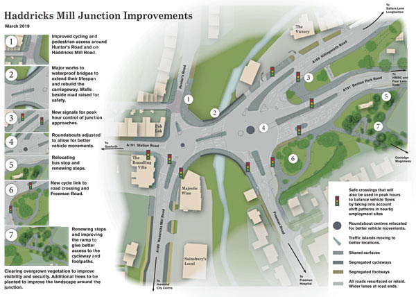
You can also download the full plans for Haddricks Mill junction.

And read more in a leaflet produced by Newcastle City Council.

Planned Newcastle Northern Access Corridor road

The works to Haddricks Mill is part of planned improvements for a key transport corridor which runs from Cowgate to the north of the city, including Blue House roundabout, Haddricks Mill and Killingworth Road.

Revised Blue House Roundabout plans

Final designs for Blue House are being developed and modelled based on recommendations from a working group set up following the backlash to original proposals in the summer of 2016.

These will be publicised this summer.

Killingworth Road ongoing works

We’re investing over £13.5m to widen the well-known pinch point at Killingworth Road.

This funding is focused on addressing some major maintenance issues including the retaining wall and ensuring the bridge over the Ouse that the Haddricks Mill junction sits on is safe for future generations.

Over-runs to the gas diversion works has meant a delay to the re-opening of Killingworth Road. Newcastle City Council would like to thank everyone for their patience during the roadworks. You can read more here.

The project received £4m from the Government’s Local Growth Deal through the North East Local Enterprise Partnership (LEP). The Local Growth Deal is supporting major capital investments to promote innovation, economic and skills infrastructure and sustainable transport as part of the North East Growth Deal.

The above news story was issued by Newcastle City Council and included on the Newcastle City Council website. It has been included here for information and does not necessarily represent the views of High West Jesmond Residents’ Association. 

FOVALD appreciation of Susan Lydia Challoner

Plaque commissioned by FOVALD’s Lending a Hand group to show appreciation to former resident who donated the ‘gap in the wall’

The Friends of the Valley, Little Dene and Little Dene Park’s (FOVALD) Lending a Hand Group has recently commissioned a new plaque to tell the story of the ‘hole in the wall’ at Little Dene Park.

On Friday 8 February Catherine McKinnell MP was invited to unveil the plaque commemorating the gift by Susan Lydia Challoner of the ‘gap in the wall’ that gives us all a short cut on to Moor Road South.

The plaque has been commissioned by FOVALD’s Lending a Hand Group that now looks after the Little Dene Park in addition to the Valley and Little Dene.

Members of FOVALD, the Lending a Hand Group and local High West Jesmond residents attended the ceremony to learn more about the generosity of Susan Lydia Challoner and the history of this part of High West Jesmond.

Who was Susan Lydia Challoner?

The plaque commemorates a lady called Susan Lydia Challoner who lived in Moor Road South between 1936 and 1953.

The park, which we now know as Little Dene Park, was constructed by the Newcastle City Council in 1952-53.

Mrs Challoner, who died in that year, bequeathed the money to pay for the entrance from Moor Road South.

The ‘hole in the wall’ has become a very well used route for residents in Gosforth and High West Jesmond.

The original plaque commemorating Mrs Challoners gift disappeared around 1990.

As part of FOVALD’s environmental improvement plan for the Little Dene Park they decided to reinstate the plaque.

FOVALD’s Lending a Hand Group tapped into resident’s memories to find the wording that best reflected the original and they commissioned the new plaque from Thorpes of Gosforth.

FOVALD caring for our green spaces

FOVALD (Friends of the Valley, the Little Dene and Little Dene Park) a small voluntary organisation based in High West Jesmond.

They have adopted the Valley from the City Council and the Little Dene Park from the City’s Freemen (it is part of the Town Moor).

FOVALD also look after the original Little Dene as a nature resource.

On Tuesday mornings, FOVALD organise’s a group called Lending a Hand that does the maintenance & improvement work on the green spaces in this part of High West Jesmond, as well as keeping all the other verges and paths in the area tidy.

Many thanks to FOVALD and to the Lending a Hand group for their ongoing work to enhance our community green spaces.

Chris Morgan also writes to share some history

When the High West Jesmond estate was first laid out Moorfield stopped at the now triangular junction with Lodore Road.

The main way into HWJ from the Great North Road was by the path that cut across the Little Moor.

However there must also have been a path leading from that corner to the bottom of Moor Road where the Little Bridge still crossed the Craghall Burn. My mother remembered playing in the stream at that point.

It must have been very soon after WW1 that Moorfield was extended through to the Great North Road and the stream went into a culvert to emerge in the grounds of the old house, Little Dene.

Boundary of Newcastle

At this time the stream formed the boundary between the City and County of Newcastle upon Tyne and the County of Northumberland. On the surface the stone wall was the boundary.

The Little Moor is part of the Town Moor owned by the Freemen, but this part of the Little Moor was now isolated.

Little Park

In 1952 the Freemen released the area north of Moorfield to form a Coronation Park (there must have been thousands of others across the nation, it was a time of great euphoria and celebration), although it wasn’t known as such. We all called it the Little Park.

The flower beds created were almost totally of clay and little grew for decades! I believe they may still be a challenge.

When the park was laid out there was a path extending around the perimeter with a dead end spur ending beside the stone wall. If memory serves correctly my friend Tony Devine’s bike/trike/scooter ran away down the gradient and he crashed into the wall, badly breaking his arm.

Hole in the wall

A clamour grew to have the wall opened up to allow free passage onto Moor Road South. It may not have happened for 2 or 3 years after 1953.

A simple plaque was positioned and the name Challoner was on it. There may have been another name as well.

Twice a day nuns from the convent just up Moor Road walked through the gap to and from La Sagesse school at the top of Matthew Bank.

HMO licensing

Some residents have asked what the rules are regarding HMO’s (housing in multiple occupancy).

There are a number of pieces of legislation that apply and these are set out on the Newcastle City Council website.

This legislation includes Article 4 Directions and the Mandatory Licencing of HMO’s (housing in multiple occupancy).

Both of these regulations apply in High West Jesmond.

We set out a brief summary below, and on our HMO page on this website but you should read the Newcastle City Council webpages for full details.

Article 4 Directions

An Article 4 direction removes various forms of permitted development right normally associated with a property.

The result of Article 4 Directions mean that in certain parts of Newcastle upon Tyne, planning permission is required to change use from Class C3 (family dwellinghouses) to Class C4 (HMO – housing in multiple occupancy).

The reasons for the directions are normally to prevent a form of development taking place that would be harmful to the character or amenity of the area.

Extant planning policy in Newcastle upon Tyne sets out where the change of use from a family dwellinghouse to a house in multiple occupation would result in the loss of a good quality, spacious and convenient dwelling suitable for occupation by a family by reason of its location and level of amenity, prejudicing the objective of providing attractive, sustainable and balanced communities.

The intensification of use of property could also have an adverse impact on residential amenity, through increased noise and activity.

High West Jesmond is covered by Article 4 Directions and there is a presumption against further housing in multiple occupancy as this would result in the loss of a good quality, spacious and convenient dwelling suitable for occupation by a family.

Read a summary on Article 4 Directions on our HMO page on this website.

Mandatory Licensing for HMO’s

The legal minimum standards and conditions for HMO’s are set out in the Housing Act 2004 and national Regulations. The HMO Management Regulations cover the legal duties for the day to day running of HMO’s

All licences granted are subject to conditions which the licence holder must comply with either immediately or within a specified period of time.

It is a criminal offence to let a property that is required to be licensed as a HMO without applying for a HMO licence.

Read a summary on Mandatory Licensing for HMO’s on our HMO page on this website.