HWJRA statement on proposals for possible road closures

Statement by High West Jesmond Residents’ Association regarding proposals for possible road closures in High West Jesmond

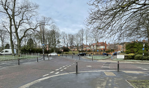
The western end of Moorfield as it meets the Great North Road, High West Jesmond, Newcastle upon Tyne

High West Jesmond Residents’ Association (HWJRA) is aware that, at a public meeting held in Gosforth last week, proposals for possible future road closures were shared with members of the public.

Many of these proposals, including a possible closure of the west end of Moorfield, would have a significant impact on High West Jesmond so it is of great concern to us that none of the 600 households in High West Jesmond received a letter inviting them to the meeting.

We will be taking this matter up directly with the council and insisting that High West Jesmond residents are fully involved in any consultation process.

At this stage we don’t feel it would be appropriate to comment on the specific proposals as they haven’t been properly explained to us and we haven’t had the opportunity to share them with local residents to gauge opinion.

It is now our intention to get this information from the council and share it through our usual communication forums.

We have been assured by our local councillors that the proposals were initial ideas only and that full consultation will take place before anything is implemented.

About High West Jesmond Residents’ Association

High West Jesmond Residents’ Association (HWJRA) was established to support the residents of 600 households in the local area.

You can read more on the High West Jesmond Residents’ Association page.

Council to apply for new traffic enforcement powers following consultation

Proposals for council-led camera enforcement of the yellow box restriction at the junction of Christon Road and Great North Road, in Gosforth.

The following news release was issued by Newcastle City Council:

“Newcastle City Council is applying to government for additional enforcement powers covering a range of traffic regulations that are currently the responsibility of the police.

The government invited councils to apply to take over these responsibilities and, as part of the process, councils had to consult on proposals that set out how this would be beneficial and improve road safety in at least one location.

Consultation

A six-week consultation on proposals for council-led camera enforcement of the yellow box restriction at the junction of Christon Road and Great North Road, in Gosforth, has recently been completed.

The majority of those who responded supported the proposals, with some raising additional concerns about traffic issues in other areas.

A number of safety concerns had previously been raised regarding the Christon Road and Great North Road junction and the fact that the yellow box is often blocked by vehicles at peak times.

This has resulted in some drivers using the wrong side of the road to avoid having to wait to turn right out of Christon Road and travelling through the junction at times when the pedestrian lights are on green, signalling that it is safe for people to cross.

Cllr Jane Byrne, cabinet member for a connected clean city at Newcastle City Council, said:

“We’re grateful to the people who took the time to respond to this consultation to share their views on whether enforcement would help to make this junction safer.

“This is a busy junction both in terms of vehicles and the number of people using the pedestrian crossing.

“There’s been a lot of concern about safety at this junction, particularly for local school children who use the crossing on their walk to school.

“We believe that enforcement at this location will help to keep the junction clear and reduce the number of drivers carrying out dangerous manoeuvres, making it safer for everyone.”

Council to apply for enforcement powers

Following the outcome of the consultation, the city council will now apply to government for the enforcement powers.

If approved, the council will be able to install cameras and begin enforcement at the junction of Christon Road and Great North Road, although for the initial six months drivers who breach the traffic restriction will be issued with a warning letter only for a first offence.

Other areas in the city could also be considered for enforcement action where this could also lead to improved road safety.

Any further proposals would be subject to additional public consultation, although there would be no further requirement to apply again to government.”

The above news story was issued by Newcastle City Council and is available to read on the Newcastle City Council website. It has been included here for information and does not necessarily represent the views of High West Jesmond Residents’ Association. 

New bus priority measures for Gosforth High Street to be introduced

New bus priority measures are set to be installed on a key bus route to improve public transport.

The following news release was issued by Newcastle City Council:

“Plans are underway to extend the bus lane on the northbound section of Gosforth High Street, with the current bollards removed, within the coming weeks.

One lane of traffic from Moorfield to Salters Road

The immediate plans will see one lane of traffic each way retained through the main stretch of the high street, with bus priority measures and cycling provision where space allows.

This would see bus lane provision extended northbound along Gosforth High Street, from Moorfield towards Salters Road at its junction with Church Road, to improve journey times and bus reliability on one of the busiest routes for public transport from the city.

The plans are part of a phased approach to the High Street which would see bus priority measures installed in the coming weeks, with a second phase looking at the long-term options for this key shopping destination.

The re-allocation of road space would see cycling provision remain in place from Moor Crescent up to St Nicholas Avenue. Cycling provision from St Nicholas Avenue to Salters Road would be removed in the short-term, with longer-term plans to better connect this part of the High Street with more ‘quiet routes’ for cycling on connected side streets as part of a second phase of improvement works. Other longer-term proposals include improvements to public realm space with a parklet for the community to enjoy, improved cycle parking facilities, better-placed and improved bus stops, as well as green infrastructure to improve biodiversity and air quality in the local area.

Cllr Jane Byrne, cabinet member for a connected, clean city said:

“The plans we have put forward greatly improves bus services on a key bus route from the city, removes the bollards which people have asked us to do, as well as develops a long-term future for Gosforth High Street, to make it greener, more accessible and improves the look and feel of a key shopping area in the city.

“We’re taking a phased approach to this high street, with the immediate focus on improving bus priority measures as we want Newcastle to be a clean, connected city and having an efficient public transport network, particularly on one of the major routes from the city, is a key part of this and is part of our priorities to achieve net zero.

“Gosforth High Street is one of the narrowest high streets in the city and we want to make best use of the space available. Increasing the bus lane provision means we won’t be able to widen pavements and provide cycling along the whole of the High Street, so we’ll be looking at improving connectivity for people walking, wheeling and cycling to this important shopping area as part of the next phase of works.

“We’ll be setting out further proposals on the long-term future of the high street soon and I invite everyone to have their say.”

Using Experimental Traffic Regulation Orders (ETROs), it is intended to install the bus priority changes in the coming weeks. Public consultation would take place for the first six months of the scheme being implemented. This would allow the council to trial the scheme and gauge public feedback, as well as ask the public for their views on the long-term future of the High Street.

Journey time data, which has been collected over four years, show that there has been minimal impact on the travelling public with the traffic reduced to two lanes through the High Street. Southbound journey times have improved on the am peak, with no change on the pm peak. Northbound journey times haven’t been affected on the am peak, with a small increase on average on the pm peak.

Bus priority measures, in locations such as the Great North Road, are an essential part of the proposed Enhanced Bus Partnership across the North East region which will see improvements to bus reliability, services and bus fares. 

Information for the public is being prepared, including drop-in events, which will be announced soon, ahead of the scheme being implemented in Spring 2023. The measures could be in place for up to 18 months while the council review the findings from data and public feedback on the scheme, while bidding for the funding to deliver a long-term enhancement to this area.”

The above news story was issued by Newcastle City Council and is available to read on the Newcastle City Council website. It has been included here for information and does not necessarily represent the views of High West Jesmond Residents’ Association. 

Walk the bounds 2019 – a tour of High West Jesmond

Join us for a fascinating tour of High West Jesmond and learn more about the history of our community

We are delighted to invite you to our 2019 walking tour of ‘the bounds’ of High West Jesmond.

This will once again be led by Chris Morgan who residents will remember led us on a facinating tour during 2018.  Chris has also kindly shared some of his photographs of High West Jesmond’s past that we have featured on this website.

Date: Sunday 2 June 2019

Time: 10.30am

Meeting place: outside Delicious Decadence, Newlands Road, NE2 3NT

The tour will take approximately 2 hours and will explain the last 200 years of this special area on the border of Jesmond and Gosforth.

It will be illustrated with many old photographs and tales from Chris Morgan’s personal memory and those of his mother who played here before many of the houses were built.

We look forward to seeing you on Sunday 3 June.

Download a copy of the Walking the Bounds of High West Jesmond event poster here. 

Walk the bounds – a tour of High West Jesmond

Join us for a fascinating tour of High West Jesmond and learn more about the history of our community

We are delighted to invite you to a walking tour of ‘the bounds’ of High West Jesmond led by Chris Morgan who has already kindly shared some of his photographs of High West Jesmond’s past that we have featured on this webesite.

Date: Sunday 3 June 2018

Time: 10.30am

Meeting place: outside Delicious Decadence, Newlands Road, NE2 3NT

The tour will take approximately 2 hours and will explain the last 200 years of this special area on the border of Jesmond and Gosforth.

It will be illustrated with many old photographs and tales from Chris Morgan’s personal memory and those of his mother who played here before many of the houses were built.

We look forward to seeing you on Sunday 3 June.

Download a copy of the Walking the Bounds of High West Jesmond event poster here

Streets for People – HWJRA submits views from residents’ meeting

During the consultation period of proposed changes to streets in High West Jesmond as part of the Streets for People initiative HWJRA held a residents meeting on Monday 13 November 2017.

The meeting was held at Jesmond Library and was well attended.

HWJRA organised the event so that residents had the opportunity to find out more about the proposals for Moorfield and Ilford Road, ask questions and hear others views.

Following the meeting HWJRA submitted the views from the residents to Streets for People so that these could be taken into account before the consultation period closes on 30 November 2017.

A copy of the HWJRA submission is shown below.

The Moorfield and Ilford Road proposal from Streets for People

Read a summary of the proposal in the Moorfield Information Sheet:

Your feedback is wanted

The Streets for People initiative want to hear from you and you can provide feedback via their website. You have until 30 November 2017 to submit your feedback.

Residents’ views as submitted by HWJRA

The following in a summary of the HWJRA Meeting which was held to discuss the Streets for People Proposal – 13/11/2017:

Present:

Ilford Rd/Moorfield (15 residents)
Lodore/Treherne/Albemarle/Kingswood/Newlands (13 residents)
Albury/Honister/Woodthorne (4 residents)
Councillor Henry Gallagher
Total (32 residents plus 1 councillor)

The S4P proposal was explained in detail and then the group were invited to discuss and express their views, looking at each of the main aspects of the proposal separately.

1. Ilford Road/Moorfield Junction

All agreed that there was an issue of safety at this junction and welcomed the proposal to improve this.

The group was split 1/3 in favour, 1/3 against, 1/3 not sure about the roundabout design. The group wasn’t against a roundabout “per-se” but was concerned about some of the details.

Residents’ principal concern at this junction is pedestrian and cyclist safety – in particular it is difficult for pedestrians (particularly those with pushchairs or in wheelchairs) to cross over Ilford Road on the northern side of the junction.

The previous redesign of Ilford Road has led to poor visibility on Ilford Road on the northern side of the junction as traffic heading north waits for traffic heading south in the approximate location of the proposed roundabout. This should be tackled as part of any redesign of the junction.

Suggestions from the group

– Getting cars to slow down in all 4 directions is felt to be a good approach.

– Group would strongly support a raised platform at this junction (similar to the one at the junction of Moor Road South and the Grove). This could include a roundabout, but if it did then visibility and accessibility would need to be improved.

– Double yellow lines should be added around all 4 corners of the junction as cars currently park too close to the junction.

– A well located pedestrian crossing on the north side, going across Ilford Road, would be very beneficial for pedestrians and further slow traffic on Ilford Road.

– Dropped kerbs should be added at crossing points (except where there is a raised platform).

– Junction should be re-aligned east to west to improve safety.

2. Re-laid pavement and crossing points along Moorfield

Group was 100% in favour of this, subject to the width and location of the crossing points coinciding with existing points and the materials used being sympathetic to the area.

Suggestions from the group

Also renew pavement on north Moorfield between Treherne Road and Great North Road (using same materials as above) as it is in a similarly poor condition and a large puddle now appears where the old pavement meets the new pavement at the west end of Moorfield.

3. Narrowing of Moorfield

Residents strongly support reducing speeding traffic on Moorfield however they are strongly against doing this by narrowing the road.

The reasons for this were:

The visual amenity of a wide road is much appreciated by local residents and they would be very reluctant to see this changed.

Residents on Ilford Road feel that this road has become more dangerous since it was narrowed. There has been no noticeable decrease in speeding traffic, a notable increase in damage to cars (clipped wing mirrors etc) and overall the road feels more dangerous.

There was some concern that, particularly at night when there are less vehicles parked on Moorfield, it might look like a few cars have parked in the middle of the road and this could be disorientating and unsafe.

Concerns were also raised (via letter to the meeting) that Moorfield would become more dangerous to cross for pedestrians including many dog walkers who use the Little Moor.

Suggestions from the group

Residents were very much in favour of using an alternative approach to reduce the problem of speeding on Moorfield. A number of ideas were suggested and the following received strong support (in order of popularity).

– Introduce raised platforms at junctions of Moorfield and all or some of its side roads (Newlands Road, Kingswood Avenue, Albemarle Avenue, Treherne Road and Lodore Road). These would be similar to the junction of Moor Road South and the Grove

– Introduce nicely designed signage on the road or side of the road (maybe done by West Jesmond school) to make it clear that these are 20mph residential streets

– Introduce a “continuous pathway” along the northern side of Moorfield to reduce the speed at which cars enter and exit the side streets

– Introduce a pedestrian crossing on Ilford Road and possibly Moorfield

– Introduce an advisory “speed checker” sign halfway along Moorfield

4. Cycle Path along Moorfield

The group was split 2/3 “against” and 1/3 “unsure” about a cycle path. Nobody was in favour.

The reasons given for the opposition were:

Residents (including a number of cyclists) feel that cycling is already safe on Moorfield because of its width, and that there are other areas of Jesmond/Newcastle where the addition of a cycle path would be far more beneficial.

The cyclists in the group felt that they would be unlikely to use the cycle path as it was fairly narrow for two way cycle traffic and right next to parked cars. They would prefer to cycle on the wider roadway, particularly if speed of traffic is reduced.

Cyclists who live on the side streets off Moorfield also said that they would not want to have to cross the road between parked cars to get to a cycle lane on the south side of the road.

All felt that focus should be on reducing speed of traffic and improving the Ilford Road/Moorfield junction. Doing this would automatically improve safety for both cyclists and pedestrians.

Suggestions from the group

Remove the cycle lane from the proposal and focus on speed reduction and junction safety to enhance the cyclist and pedestrian experience.

5. Pavement widening at Moorfield/Treherne

The group was opposed to this as it was not felt to be a dangerous junction and there would be a net loss of parking space if the proposal went ahead.

That said, the group were concerned about the impact of dangerous and inconsiderate parking at all the junctions of Moorfield and its side streets (particularly where dropped kerbs are being blocked).

Suggestions from group.

Leave pavement at current width but introduce yellow lines on corners of Moorfield and its side streets to keep dropped kerbs fully accessible.

6. Removal of parking/redesign of junction at west end of Moorfield

The group was 100% in favour of this. Parked cars at this junction are making it dangerous for drivers, cyclists and pedestrians.

Suggestions from the group

Extend the proposed “no parking” area up to where Moorfield meets Lodore Road.

The group then discussed some of the other suggestions that have already been made on the S4P consultation website as follows:

7. Closing the junction of Moorfield and Great North Road

The group was split 38% in favour, 50% against and 12% don’t know on this proposal (Moorfield residents were split 50%/50%).

It was suggested that the impact of any changes at Blue House Roundabout would need to be factored in to any decision and that, during the construction phase of any project at BHR, a temporary closure might be appropriate.

8. Residents’ parking

Opinion was split 47% in favour, 41% against, 12% don’t know on this issue.

People on Ilford Road and Moorfield have been most directly impacted by the increase in “park and ride” that is clearly happening in the area and, as a consequence, are more likely to favour residents’ parking.

It was agreed that this issue should be looked at once the Streets for People (and possibly Blue House Roundabout) projects have been completed.

It was also suggested that Nexus should be encouraged to get the Regent Centre park and ride facility better used – possibly by bringing Regent Centre into Zone 1.

9. Ilford Road

Whilst the S4P project only directly impacts on Ilford Road at its junction with Moorfield, concern was expressed about this road and the continued high speed of traffic, damage to vehicles and difficulty at junctions – particularly at Lodore Road.

Residents were asked what their opinion would be on closing Ilford Road to through traffic by blocking the road at (for example) the point where Ilford Road becomes Rectory Road. T

he group was strongly opposed to this suggestion as they felt it would simply shift the problem of rat running elsewhere.

It was agreed that a submission on behalf of residents would be made by HWJRA to the S4P group.

Streets for People information
You can read more of the background to the Streets for People initative on our Streets for People page.